India Puts Its Foot Down: 27 Places in Arunachal Get Official Names on the Map — And China Won’t Like It

By Naitik Pathak

Published On: August 8, 2026

--- # India Puts Its Foot Down: 27 Places in Arunachal Get Official Names on the Map — And China Won't Like It **India just made a move that sends a clear message — and no one needed to fire a single shot to do it.** The Indian government has formally identified 27 places and geographical features in Arunachal Pradesh on the official Survey of India map, a quiet but pointed assertion that strikes right at the heart of Beijing's long-running campaign to rename Indian territory. The announcement, made on August 7, came through the Press Information Bureau and covers a wide sweep of locations — from remote high-altitude passes along the Line of Actual Control to towns, lakes, villages, and even a war memorial. **Names That Carry Weight — and History** Some of these 27 places are not just dots on a map. They are living chapters of India's most defining border conflicts. Long Ju, situated along the Line of Actual Control, witnessed one of the earliest India-China border confrontations back in 1959 when Chinese forces entered the region. Thag La, the mountain pass inseparably linked to the opening battles of the 1962 India-China war, has also been formally placed on the official map. These are not arbitrary additions. Every one of these entries tells you something about how much contested history this land holds. Also included are several strategically significant high-altitude passes — Dzo La, Riza La, and Pukur La — along with Sambho Sarovar, a high-altitude lake, and the Sher-e-Thapa Memorial, which commemorates 1962 war hero Trilok Singh Thapa. Jairampur in Changlang district, a key logistics hub supporting the movement of security forces towards eastern Arunachal Pradesh and the Myanmar border, is among the identified locations as well. **India's Answer to China's Renaming Game** This move doesn't come out of nowhere. China has periodically released lists of what it describes as "standardised" names for places in Arunachal Pradesh, which it refers to as Zangnan — issuing its first list of six locations in 2017, followed by 15 places in 2021 and 11 more in 2023. Each time, India has pushed back. New Delhi has described Beijing's renaming exercise as "vain and preposterous," maintaining that Arunachal Pradesh "was, is, and will" remain an integral part of India and that assigning "fictitious names" to Indian territory cannot alter facts on the ground. What India is doing now is different though. Rather than just issuing a statement in response to Beijing, it is taking a proactive step — formally anchoring these names in the country's own official cartographic record. That's a more durable kind of assertion. **A Decision Made Together** The decision followed consultations between the Centre and the Arunachal Pradesh government, which matters. This wasn't handed down unilaterally from New Delhi. It reflects a shared understanding that standardising these names serves real administrative, cartographic, and public awareness purposes — not just diplomatic ones. Places like Kamlang Nagar near the Kamlang Wildlife Sanctuary, Sunpura, Shivaji Nagar, and Buddhamandir are now formally on the record, giving citizens, officials, and security forces a common, authoritative reference. A name may seem like a small thing. But in border diplomacy, what you call a place — and who gets to call it — is never really a small thing at all. India has made its position clear, not with rhetoric, but with a map. --- --- **② ARTICLE TAGS** Arunachal Pradesh, Survey of India, official map, 27 places, China renaming, India China border, Line of Actual Control, Long Ju, Thag La, 1962 war, border dispute, Zangnan, cartography, Jairampur, Sambho Sarovar, Sher-e-Thapa Memorial, Kamlang Nagar, mountain passes, India sovereignty, Changlang district, Upper Subansiri, Trilok Singh Thapa, border confrontation, India China relations, Press Information Bureau, geographical features, standardised names, Arunachal identity, LAC, Northeast India --- **④ SOCIAL MEDIA HASHTAGS** #ArunachalPradesh #SurveyOfIndia #IndiaChina #LinOfActualControl #ThagLa #LongJu #ChinaRenaming #IndiaMap #BorderDispute #Zangnan #1962War #ArunachalOurOwn #IndiaStandsStrong #NortheastIndia #JairamPur #SambhoSarovar #SherEThapaMmemorial #IndianSovereignty #AbotaniTV #ArunachalIdentity
---Advertiment ---

India just made a move that sends a clear message — and no one needed to fire a single shot to do it.

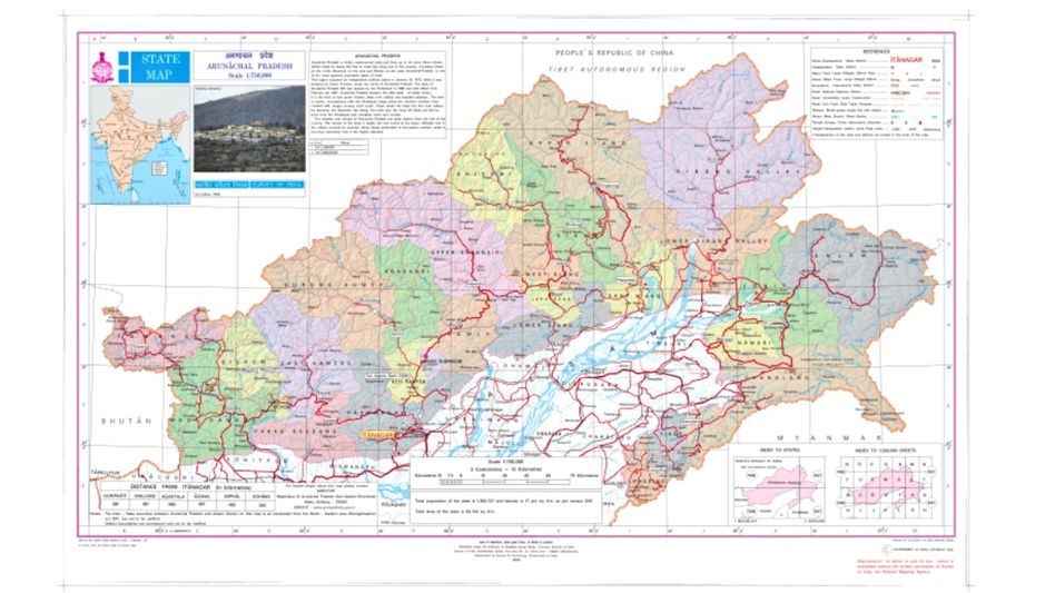
The Indian government has formally identified 27 places and geographical features in Arunachal Pradesh on the official Survey of India map, a quiet but pointed assertion that strikes right at the heart of Beijing’s long-running campaign to rename Indian territory. The announcement, made on August 7, came through the Press Information Bureau and covers a wide sweep of locations — from remote high-altitude passes along the Line of Actual Control to towns, lakes, villages, and even a war memorial.

Names That Carry Weight — and History

Some of these 27 places are not just dots on a map. They are living chapters of India’s most defining border conflicts. Long Ju, situated along the Line of Actual Control, witnessed one of the earliest India-China border confrontations back in 1959 when Chinese forces entered the region. Thag La, the mountain pass inseparably linked to the opening battles of the 1962 India-China war, has also been formally placed on the official map. These are not arbitrary additions. Every one of these entries tells you something about how much contested history this land holds.

Also included are several strategically significant high-altitude passes — Dzo La, Riza La, and Pukur La — along with Sambho Sarovar, a high-altitude lake, and the Sher-e-Thapa Memorial, which commemorates 1962 war hero Trilok Singh Thapa. Jairampur in Changlang district, a key logistics hub supporting the movement of security forces towards eastern Arunachal Pradesh and the Myanmar border, is among the identified locations as well.

India’s Answer to China’s Renaming Game

This move doesn’t come out of nowhere. China has periodically released lists of what it describes as “standardised” names for places in Arunachal Pradesh, which it refers to as Zangnan — issuing its first list of six locations in 2017, followed by 15 places in 2021 and 11 more in 2023. Each time, India has pushed back. New Delhi has described Beijing’s renaming exercise as “vain and preposterous,” maintaining that Arunachal Pradesh “was, is, and will” remain an integral part of India and that assigning “fictitious names” to Indian territory cannot alter facts on the ground.

What India is doing now is different though. Rather than just issuing a statement in response to Beijing, it is taking a proactive step — formally anchoring these names in the country’s own official cartographic record. That’s a more durable kind of assertion.

A Decision Made Together

The decision followed consultations between the Centre and the Arunachal Pradesh government, which matters. This wasn’t handed down unilaterally from New Delhi. It reflects a shared understanding that standardising these names serves real administrative, cartographic, and public awareness purposes — not just diplomatic ones. Places like Kamlang Nagar near the Kamlang Wildlife Sanctuary, Sunpura, Shivaji Nagar, and Buddhamandir are now formally on the record, giving citizens, officials, and security forces a common, authoritative reference.

A name may seem like a small thing. But in border diplomacy, what you call a place — and who gets to call it — is never really a small thing at all. India has made its position clear, not with rhetoric, but with a map.


 HASHTAGS

#ArunachalPradesh #SurveyOfIndia #IndiaChina #LinOfActualControl #ThagLa #LongJu #ChinaRenaming #IndiaMap #BorderDispute #Zangnan #1962War #ArunachalOurOwn #IndiaStandsStrong #NortheastIndia #JairamPur #SambhoSarovar #SherEThapaMmemorial #IndianSovereignty #AbotaniTV #ArunachalIdentity


Leave a Comment